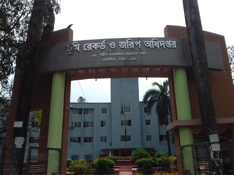
Land Records and Survey Department Job 2024. Land Records and Survey Department under the Ministry of Land Job Circular has been found on my website. Land Records and Survey Department also published a new job circular also published Land Records and Survey Department’s official website. Land Records and Survey Department Job under the Ministry of Land has now published a very attractive job circular. The Land Records and Survey Department is the most important department and dependable service team in Bangladesh.
Land Records and Survey Department Job
Ministry of Land and Land Records and Survey Department Job circular, job result, and related information are found on my website. Ministry of Land is giving to people for exciting career opportunities of this Land Ministry. Ministry of Land thinks that young and energetic people are the key to success in this government job. If you want to build your career, you can apply for this job.
The Land Records and Survey Department offers a plethora of job opportunities for individuals seeking engaging and meaningful careers. With its crucial role in land management and spatial data collection, this department serves as a cornerstone for various sectors including urban planning, infrastructure development, and environmental conservation. Land Records and Survey Department Job 2024.
Land Records and Survey Department Job Details
Land Ministry Job Summary:
■ Job Title: Sub-Surveyor, Computer Operator, Boundary Amin, Printer, Office Assistant cum Computer Operator etc.
■ Job Description: This job position is experienced for further review and selection purposes.
■ Published Date: March 14, 2024
■ Application Online Start: March 24, 2024
■ Application Deadline: April 30, 2024
■ Educational Qualification: See the Circular
■ Job Nature: Full-time
■ Job Type: Government (Land Records and Survey Department)
■ Employment Type: Permanent.
■ Education Qualification: See Job Advertisement
■ Job Experience: See Job Advertisement
■ Gender: Both (Male & Female)
■ Compensation and Benefit: As per the Government 8th Payscale.
■ How to Apply: Apply to [dlrs.teletalk.com.bd]
■ Job Location: Anywhere in Bangladesh
■ Age Limit: 30 years and 32 Child of Freedom Fighter
Land Records and Survey Department Job Notice

Land Records and Survey Department Job Offer
Working at the Land Records and Survey Department entails diverse responsibilities, ranging from cadastral mapping and land registration to conducting topographic surveys and maintaining geospatial databases. Professionals in this field utilize advanced technologies such as Geographic Information Systems (GIS), remote sensing, and Global Positioning System (GPS) to accurately map and document land features. Land Records and Survey Department Job 2024.
Moreover, employment at the department provides avenues for personal and professional growth. Employees have the chance to contribute to vital projects that impact communities and shape landscapes. The collaborative work environment fosters learning and innovation, encouraging individuals to develop specialized skills and expertise in geospatial analysis, land administration, and cadastral surveying.
Furthermore, careers at the Land Records and Survey Department offer stability and advancement opportunities. With ongoing initiatives aimed at modernizing land management systems and enhancing data accuracy, there is a growing demand for skilled professionals in this field. Whether one’s interest lies in fieldwork, data analysis, or policy development, there are diverse roles available to suit different skill sets and career aspirations.
Land Records and Survey Department Job News
In summary, joining the Land Records and Survey Department opens doors to fulfilling careers where individuals can make tangible contributions to society while honing their skills in geospatial technology and land management. With its pivotal role in shaping land policies and facilitating sustainable development, this department presents an exciting and rewarding career path for those passionate about geography, technology, and public service.
The Department of Land Record and Survey is the Joint Directorate of Land Record and Survey Department under the Ministry of Land. Bengal Tenancy Act ( 1885 ) relating to the ownership of the land under the management of the work of preparing the map and ledger ” Board of Revenue ” in control ” of Land Records and Agriculture ” is the creation of the department in 1884.
In 1888 Land Record Department was established as an independent department. The survey work Survey of India was nyastha on. A survey was done in 1919 on the land records of the Department of Land Records and Survey Directorate Nyastha and as it is converted. In 1975 it was turned into a department and office renamed Department of Land Records and Surveys.
Survey and Settlement Department at the time of the survey was to head office in Kolkata. After partition temporarily Barisal district Brown Compound Survey Department Office is established.
Land Records and Survey Department Job Update
The Vision of Land Records and Survey:
To develop modern Land Records Surveys and management system of Bangladesh by the digitalization of the existing system with the help of Information and Communication Technology to meet the present democratic government’s “Vision 2021” which will ensure a corrupt-free, sustainable, pro-people error-free land administration system.
The mission of Land Records and Survey
- To develop the online survey and Record management system with the help of Information and Communication Technology.
- To create a digital land survey map and Records of Right (ROR) database through using modern technology.
- To develop skills in Land administration.
- To provide highly security-enabled Records of Rights (ROR) for the land owner.
- To develop Surveying, Mapping, and Land Development tax systems.
- To computerized land management system through digitizing of the map including ROR.
- To make institutional reform, human resource development, and the introduction of measures for the entire country on a long-term basis through implementation of integrated development of land administration (by providing one-stop service).
Functions of Land Records and Survey
- To prepare and implement of program of preparing maps and Records of Rights for the whole country or parts of the country through Survey and Settlement operations within a given time frame.
- To prepare Mouza Map through a cadastral survey of each village of the entire country periodically.
- To prepare, print, and publish Records of Rights (ROR) of Every Land Owner.
- To prepare, print, reprint, and publish of Map of each Thana/ Upazila, district, and the entire country.
- To establish a control point for preparing the Mouza Map through traverse surveying by using theodolite.
- To determine the country’s international borders and to prepare and print of border strip map.
- To provide technical help to the Deputy Commissioner for conflict resolution of Inter-district and inter-upazila/ thana boundary demarcation.
- To do feasibility studies of technical and geographical acceptability for the creation of a new District / Thana.
- To provide advice to the government’s land reform program, cadastral survey, and International and inter-district boundary demarcation/dispute resolution.
- To arrange and provide training on Survey and Settlement operations for the Bangladesh Civil Service (administration, police, railway, forest) and other cadre officers.

Land Records and Survey Department Job Guideline
Moreover, employment at the department provides avenues for personal and professional growth. Employees have the chance to contribute to vital projects that impact communities and shape landscapes. The collaborative work environment fosters learning and innovation, encouraging individuals to develop specialized skills and expertise in geospatial analysis, land administration, and cadastral surveying.
Furthermore, careers at the Land Records and Survey Department offer stability and advancement opportunities. With ongoing initiatives aimed at modernizing land management systems and enhancing data accuracy, there is a growing demand for skilled professionals in this field. Whether one’s interest lies in fieldwork, data analysis, or policy development, there are diverse roles available to suit different skill sets and career aspirations.


